You are here:
Wadleigh’s School Zone

Date: c.1930s-1940s
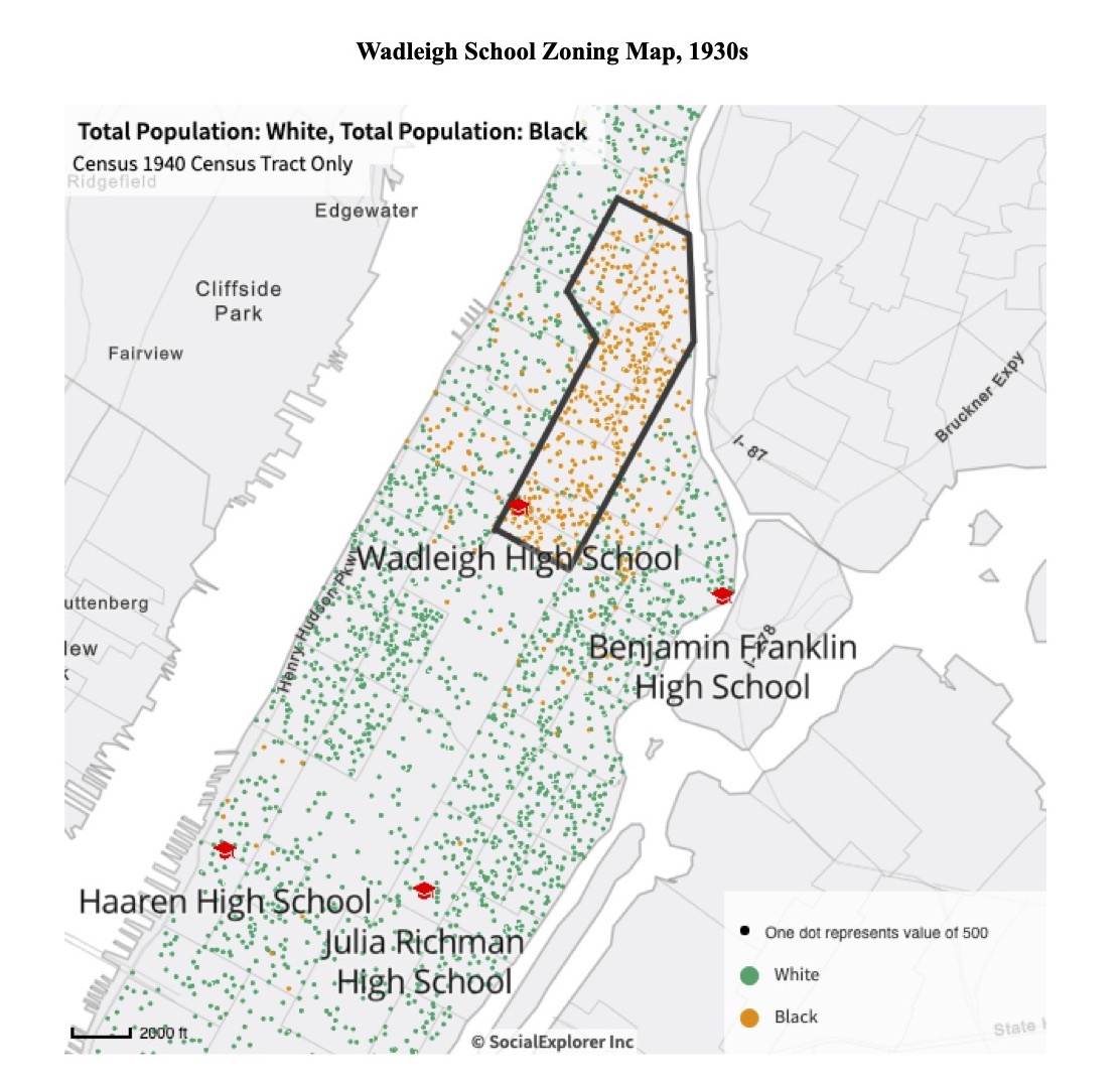
Caption: This map shows the New York Board of Education’s 1930s-1940s school zone for Wadleigh High School and US Census data for the area’s racial population as of 1940.

School zones establish where students go to school, often on the basis of where they live. This map shows how the New York City Board of Education zoned Wadleigh High School, an all-girls school, during the 1930s and 1940s. It shows the school zone lines and population data from the 1940 US Census to illustrate who was living in the area at this time.
In 1940, the US Census provided three racial categories to choose from: “White,” “Black,” and “Other.” Therefore, while this map shows clear segregation between “White” and “Black” neighborhoods in the area, it does not fully capture the diversity of the area, including people who would have identified themselves as Puerto Rican and Black or white, for example.
In the 1930s, Harlem parents and teachers challenged the segregation of schools in the neighborhood. Previously, the Board of Education had allowed students to attend high schools throughout the city. Girls living in Harlem could choose to attend Julia Richman, another all-girls high school in Manhattan, for example, or George Washington High School in Washington Heights. By drawing new school zone lines, the Board of Education decided that “students from certain schools in the neighborhood of Wadleigh should be denied admission to Julia Richman and should be advised to go to Wadleigh.”1
When Harlem teacher and parent activists pointed out that the Board of Education drew school zones to segregate Wadleigh as an all-Black school, the city’s school superintendent denied their charge. He claimed that since the Board permitted some Black students to cross zone lines, there was no intent to segregate. Yet, school authorities knew where Harlem was, knew where Black families lived, and knew that drawing school zones as they did would make Wadleigh a segregated Black school and keep other schools predominantly white.
In part because of how the Board zoned Wadleigh in 1933, enrollment at the school dramatically changed. In 1931, Wadliegh identified 25 percent of its students at the 114th Street campus as “colored.” By 1943, the school identified 70 percent of its student body as “Negroes,” and, by 1945, that number rose to 98 percent.2
Categories: Manhattan, K-12 organizing, community activism, teacher activism
Tags: Black people, white people, zoning and student assignment, racist segregation, Harlem
This item is part of "Lucile Spence and Teacher Activism" in "Black and Latina Women’s Educational Activism"
Item Details
Date: c.1930s-1940s
Creator: Matthew Kautz
Source: Data for this map comes from David Ment, “Racial Segregation in the Public Schools of New England and New York, 1840-1940,” (Dissertation: Teachers College, Columbia University), 256 and Social Explorer; U.S. Census Bureau. Total Population: White; Total Population: Black, 1940. Prepared by Social Explorer. www.socialexplorer.com (accessed October 30 2021).
Copyright: Public domain
How to cite: “Wadleigh’s School Zone,” Matthew Kautz, in New York City Civil Rights History Project, Accessed: [Month Day, Year], https://nyccivilrightshistory.org/gallery/wadleigh-zoning-map.
Questions to Consider
- How does the map above contradict the superintendent’s claim that Harlem’s schools were not segregated?
- Based on the placement of different high schools, how could you redraw the Wadleigh School Zone to promote integration?
- Thinking beyond school zones, what strategies would you propose to integrate schools, and why? What potential drawbacks would you be concerned about?
References
How to Print this Page
- Press Ctrl + P or Cmd + P to open the print dialogue window.
- Under settings, choose "display headers and footers" if you want to print page numbers and the web address.
- Embedded PDF files will not print as part of the page. For best printing results, download the PDF and print from Adobe Reader or Preview.
