You are here:
Map of Randall’s, Hart, and Blackwell’s Islands
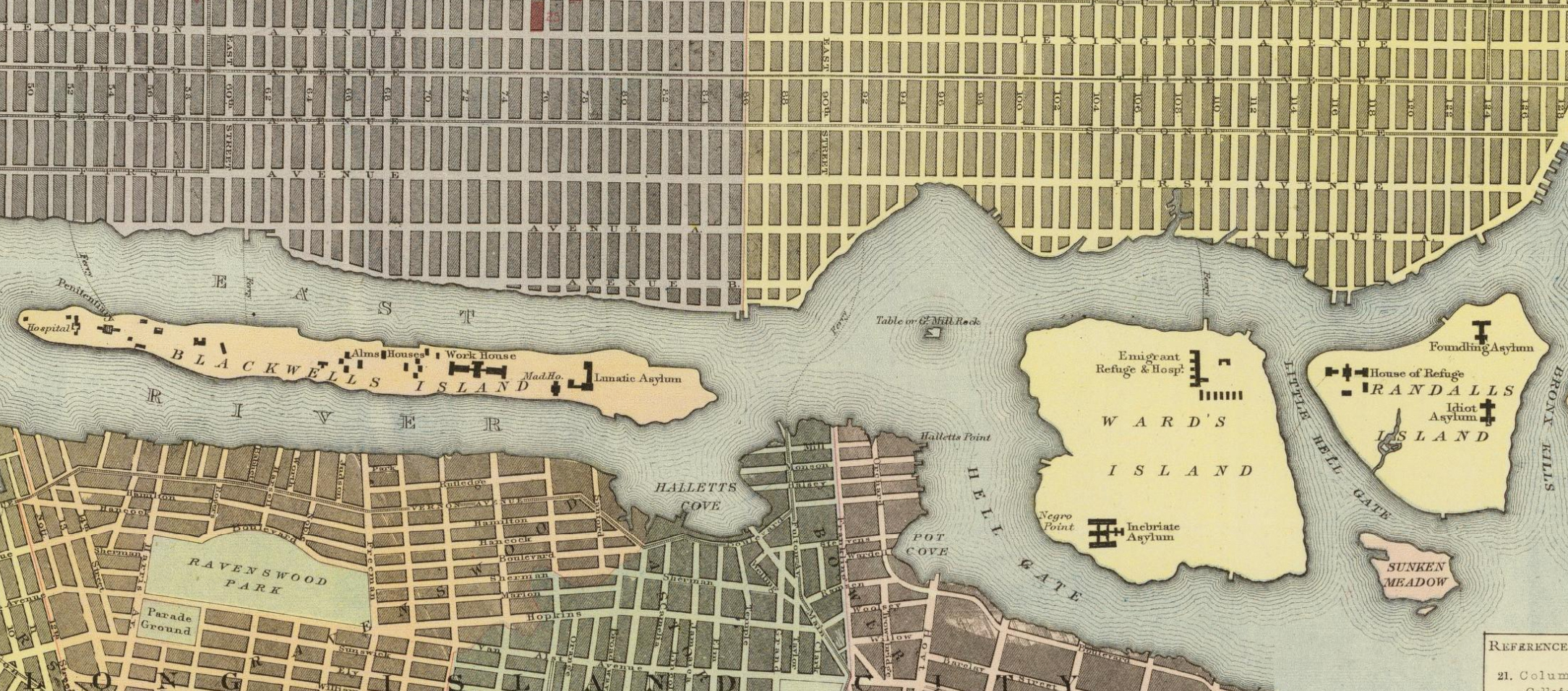
Date: 1883
Caption: A map of Blackwell’s Island (now called Roosevelt Island), Wards Island, and Randall’s Island in the East River. The map shows buildings labeled: “Hospital,” “Alms Houses,” “Work House,” “Lunatic Asylum,” “Emigrant Refuge & Hosp.,” “Inebriate Asylum,” “Foundling Asylum” (for infant children), “House of Refuge,” and “Idiot Asylum.”
In the 1830s, the City purchased Randall’s Island to use as a remote burial ground for the poor and as an almshouse. Blackwell’s and Wards Islands were purchased later, and more institutions were built on the three islands to house and care for “various indigent, criminal, ill, poor, and disabled populations.”1 Journalist W. H. Davenport visited the “Insane Asylum” and “Orphanage and Idiot Asylum,” publishing his accounts of the residents and life in those facilities.2 The articles give a view of the conditions in these early reform institutions. Non-disabled children at the orphanage were taught in classes overseen by the NYC Department of Education. Children with physical disabilities (of which there were many) were taught how to craft products that could be sold. Children at the “Idiot Asylum” also had classes with a goal of preparing them for “useful occupations.”3
As the population of New York City grew, so did populations at these institutions. In the 1930s, the City decided to connect Randalls and Wards islands together, and connect them to the surrounding boroughs with bridges. They closed many of the institutions on the island to make way for a park and recreation area.4 While facilities on Randall’s Island closed, state institutions for Disabled people and people labeled as disabled, like Letchworth Village, continued to operate. Some residential institutions still remain on the islands today, like homeless shelters and a psychiatric hospital.
David Goode et al., A History and Sociology of the Willowbrook State School, Washington, DC, American Association on Intellectual and Developmental Disabilities, 2013, 20. ↩︎
W. H. Davenport, “The Nurseries on Randall’s Island,” Harper’s New Monthly Magazine, December 1867, 6–24; W. H. Davenport, “Blackwell’s Island Lunatic Asylum,” Harper’s New Monthly Magazine, November 1867, 267–294. ↩︎
Davenport, “The Nurseries on Randall’s Island,” 22. ↩︎
Randall’s Island Park Alliance, “Historical Posts,” accessed July 9, 2023, https://randallsisland.org/timeline/. ↩︎
Categories: Manhattan, K-12 organizing, adult education
Tags: racist segregation, Disabled people, intellectual disabilities, disability labels, photography, imagery, and visual representation, institutionalization of Disabled people and people labeled disabled
This item is part of "The Beginnings of Special Education" in "Seeking Equity for Disabled Students"
Item Details
Date: 1883
Creator: Letts, Son & Co.
Source: David Rumsey Historical Map Collection
Copyright: Public domain
How to cite: “Map of Randall’s, Hart, and Blackwell Islands,” Letts, Son & Co., in New York City Civil Rights History Project, Accessed: [Month Day, Year], https://nyccivilrightshistory.org/gallery/map-nyc-islands.
Questions to Consider
- What do you notice about the facilities on these islands? How were residents similar? How were they different? How were their needs similar or different?
- What do you know about these islands? How do you get to them today? How did people get to them in the 1800s?
- Why do you think some Disabled people - like those with intellectual disabilities - were sent to institutions on islands in the river, while others - like deaf students - went to schools in Manhattan?
References
How to Print this Page
- Press Ctrl + P or Cmd + P to open the print dialogue window.
- Under settings, choose "display headers and footers" if you want to print page numbers and the web address.
- Embedded PDF files will not print as part of the page. For best printing results, download the PDF and print from Adobe Reader or Preview.